


LacDuMoulinet

raymondfn
User
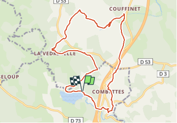

Length
11 km

Max alt
1161 m

Uphill gradient
220 m
Km-Effort
14 km

Min alt
1055 m

Downhill gradient
219 m
Boucle
Yes
Creation date :
2024-04-26 16:14:10.003
Updated on :
2024-05-09 15:59:59.377
3h10
Difficulty : Difficult

FREE GPS app for hiking
 SityTrail
IGN / Geographical institutes
SityTrail Plus
The world is yours!
About
Trail Walking of 11 km to be discovered at Occitania, Lozère, Le Buisson. This trail is proposed by raymondfn.
Positioning
Country:
France
Region :
Occitania
Department/Province :
Lozère
Municipality :
Le Buisson
Location:
Unknown
Start:(Dec)
Start:(UTM)
518759 ; 4943393 (31T) N.
Comments